There’s something magical about going to a place covered in ice. Imagine climbing and crawling over rock and stone – or through tunnels carved by glaciers – to enter a world that shimmers like a room covered in crystal. It’s breathtakingly beautiful, luminous in the light and intricately detailed with etchings made by nature.
“It’s never the same experience,” says Neil Howk, retired assistant chief of interpretation and education for Apostle Islands National Lakeshore. “It is different every day, every hour. It’s a spectacular scene that is rare and beautiful.”
But it is an endangered park experience, Howk says. As temperatures have grown warmer due to climate change, ice formations are slowly vanishing from many National Park Service (NPS) caves. For now, these amazing feats of nature can still be witnessed.
Ice caves form when frigid air is trapped into rock caverns creating spectacular ice sculptures, from icy stalactites and massive ice columns to skating rink-like floors and waterfall sheets of ice. There are also glacier caves, which are entirely formed by glacier ice – no rocks – and sea caves, which are formed after waves erode stone, carving caves by the shore.
Scientifically, ice caves and their glacier counterparts are important. “They are frozen pieces of history and time,” says Brent McGregor, co-founder of Glacier Cave Explorers, a nonprofit that does scientific research by collecting ice core samples to study microbes, pollen and other ancient debris from glacier caves.
“Ice caves offer blueprints to help scientists do climate change research,” says McGregor, who drives a blue 2013 Outback.
Ice is made of innumerable crystals. When ice freezes slowly, it can be clear if it doesn’t have too many impurities because there are larger and fewer crystals. When it freezes quickly, the ice can look white because the crystals are smaller and bunched together in larger quantities.
That makes exploring ice caves remarkably unique.
“It’s a lot different than other outdoor activities,” says Michael Fricke, a tattooed, self-described “punk rock ranger” who has worked at several national and state parks, including Lava Beds National Monument where Crystal Ice Cave is located. “It’s a whole different world down there.”
Some ice caves only have seasonal ice; others are open year-round. We’re highlighting four that you can visit this winter. Here’s how to get your ice cave on and do it right.
Experience Crystal Ice Cave through this 8-minute, 38-second NPS video:
Crystal Ice Cave
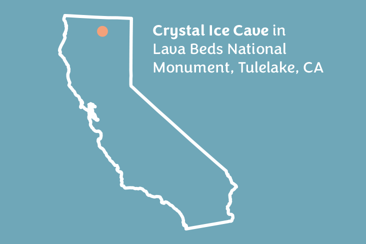
Head to Lava Beds National Monument in Tulelake, California, a town of nearly 1,000 people near the Oregon border. The Medicine Lake Volcano, which is still active, has created more than 900 lava tubes, more than anywhere else in North America, says Angela Sutton, interpretive park ranger at Lava Beds National Monument.
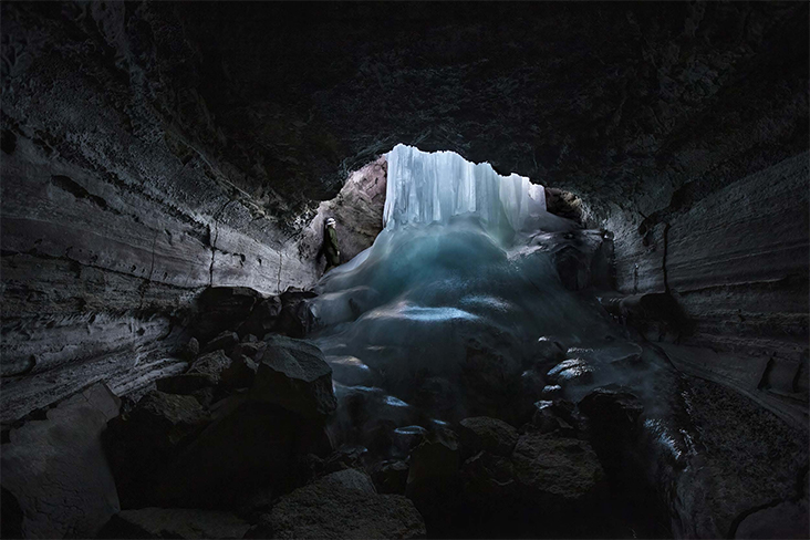
While the rest of Lava Beds is easy to visit, it’s hard to score a ticket into Crystal Ice Cave, a lava tube cave known for its breathtaking ice formations. Demand is high and access is limited to six people per tour, about 50 people per year, Sutton says, after excessive body heat from visitors began melting the ice.
If you’re lucky enough to score one of the limited spots, put on a helmet and take a guided ranger tour.
Most lava tube caves aren’t multilevel, but this one is. Like a condo building, four layers are stacked on top of each other with narrow passageways and holes that expand to large rooms. This allows more cold air to sink in and get trapped, helping larger ice formations to develop.
“When you’re going from one level to the next, it’s like you’re dropping through a chute,” Sutton says.
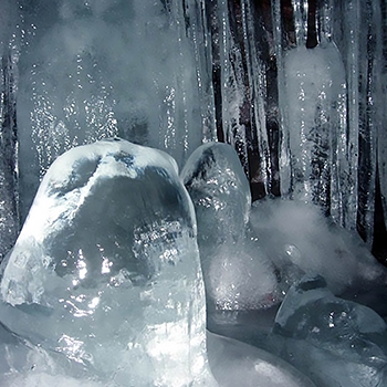
Start by crawling through a 3-foot-wide hole to climb down a 40-foot ladder into the cave. At the end is a 30-foot-long slope of solid ice. Hold on to a rope and gradually slide down the ice over a 10-foot drop.
It ends in a room with a 20-foot ice column that looks like a frozen waterfall. Across lava rocks, another ladder leads through a hole that opens into another vast room. Here, white crystals of hoarfrost hang from the ceiling.
“You’ve come through a little crawl space and pop out into a big open room looking at a big rock pile,” says Sutton, adding there are three spots to crawl in the ice cave but only for a couple of feet. “It doesn’t look like anything special, and then you turn around. There’s a ceiling right in front of your face just covered with beautiful little tiny crystals at eye level.”
It’s like looking at a snowflake under a microscope, except all the little lines, details and formations can be easily seen, Sutton says.
Cross more rocks and crawl down a hole into a long tunnel hallway. Walk through the tunnel while navigating “ice gnomes,” bubbled crystallized ice growth on the ground created by dripping water.
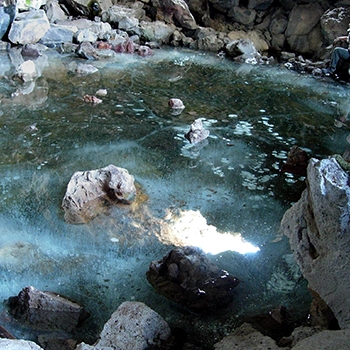
The tunnel opens into a chamber with a 15-foot ice lake. Cross the lake to a massive three-story hourglass-shaped waterfall-like ice column that sits on top of a rock pile. Then turn around and head back out of the ice cave the way you entered. The entire journey can take two to three hours.
Weather dependent, tours start in January and run through March. Anyone 12 and older can go. Book on Recreation.gov, a site that offers reservations and recreational opportunities across the U.S. from 12 federal partners.
Alternatively, Lava Beds also has Skull Cave, which offers a year-round ice floor, and seasonal ice can be found at Indian Well Cave and Heppe Ice Cave.
Ice Cave and Bandera Volcano
Known as the “Land of Fire and Ice” for its volcano and ice cave, this easily accessible prehistoric ice cave next to El Malpais National Monument sits on the sacred space where the Anasazi once lived.
More than 10,000 years ago, Bandera Volcano erupted and created a cone-like structure while forming more than 17 miles of lava tubes, including the collapsed lava tube ice cave.
Choose between several trail options to see the ice cave. All are self-guided. Keep in mind that the air is thinner here on the Continental Divide at an elevation of 8,000 feet.
Purchase tickets ($12 for adults and teens, $6 for children 6-12 years) at the trading post and choose between two paths. There’s a shorter flat route on a quarter-mile trail across a graded cinder path flanked by jagged `A`a lava flow. Walk past sinkholes and ancient Douglas firs and pinyon pine trees to go directly to the ice cave. It takes about 10 minutes one way.
For a more scenic experience, David Reinschmidt, part owner and manager of Ice Cave and Bandera Volcano, recommends taking a less direct route to see the 1,400-foot-wide Bandera Volcano before the ice cave.
A half-mile trail gradually ascends in a half-spiral around the volcano. The path takes about 20 minutes to climb and stops halfway up the 800-foot-deep volcano for an expansive look down into the pit of the cinder cone and up at the rim.
Then choose your path again. Hike about a half-mile down the other side of the volcano directly to the ice cave. Or take the more adventurous trail into the rugged lava flow past cactus, ponderosa pines and twisted alligator juniper that loops around, connecting the volcano trail to the ice cave. Each route takes about 20 minutes to get to the one-room ice cave that has an ice floor in the middle of the desert.
“There’s nothing like this anywhere in the Southwest,” says Qriosity Nouveau, who works at Ice Cave and Bandera Volcano. “It’s like a geologic glitch that shouldn’t exist here, but it does.”
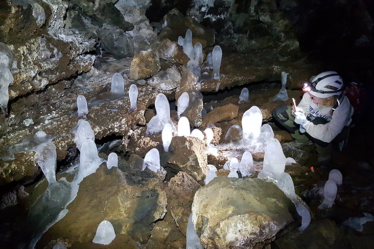
At the top of the ice cave, walk down 70 wooden steps, guided by handrails and a couple of platforms with benches, into a collapsed lava tube. Feel the temperature drop as you descend. Stand on a railed-off viewing platform and look deeper into the cave. Unlike others, you don’t need a flashlight since there’s enough natural light available.
“You’re not going through a cave structure – you’re going down into the mouth of the lava tube, which is a cave about 10 feet above the ice,” says Reinschmidt.
Made from porous lava, the cave acts as a natural refrigerator with a temperature that never rises above 31 degrees Fahrenheit. Arctic algae, lichen and moss below a 20-foot layer of ice give an aqua and lime-green hue surrounded by purple-hued rocks.
The layers of ice have been forming for more than 3,000 years, and the cave is continually generating new ice as rainwater and snowmelt seep down and freeze. “It’s a big sinkhole that trapped moisture and started building ice,” says Reinschmidt. “The ice just keeps growing.”
After exiting the cave, check out the Anasazi-era artifacts that date back 800 to 1,200 years, showcased in glass cases within a small museum and trading post. There’s also the kid-friendly chance to pan for gemstones and arrowheads with an old-time water tower and trough.
Explore an old lava tube for 2+ minutes at Bandera Volcano in this video by YouTube user WD Travels:
Mainland Ice Caves
For the adventurous, head north to the Apostle Islands, a group of more than 20 islands in Lake Superior off Bayfield Peninsula in northern Wisconsin, the native home of the Ojibwe people.
In the middle of winter, the sea caves on Lake Superior can form ice caves along the shoreline of Apostle Islands National Lakeshore at Meyers Beach.
“But the conditions have to be just right to access these ice formations,” says Julie Van Stappen, chief of resource management at Apostle Islands National Lakeshore, which means the ice caves don’t happen every year.
Ideally, there’s not a substantial amount of snow because it acts as an insulator. “The colder, the better,” says Van Stappen, who drives a red 2017 Forester. “And calm. If there’s a lot of wind and water moving around, it will prevent ice formations.”
When the weather turns colder, rangers check the ice for 10 days to ensure it is at least 10 inches thick and nothing has compromised the ice stability.
That usually happens in January. But the best ice typically occurs in February and early March, after Lake Superior has gotten colder. “Then we continually check the ice because there are times when we’ve had to close the ice caves pretty quickly,” Van Stappen says.
Go early. With limited parking at Meyers Beach, park on Meyers Road or Highway 13 and be ready for a 3-hour round-trip hike once you arrive at the ice.
Walk on water over frozen Lake Superior. The ice pops and cracks, moaning and talking, some say, as you move across. “It’s like you’re walking out into an Arctic wasteland,” says Howk. “As you walk across, it’s just a vast expanse of white.”
Look down. You may see rocks at the bottom of the lake through the blue-tinted ice that can be 18 inches thick. “It’s a little scary because it’s like going up in one of those glass skyscrapers and looking down from the 100th floor,” says Howk.
It’s slippery, so ice cleats that attach to hiking boots plus a pair of ski poles are recommended. It’s slightly over a mile to reach what is known as First Point, where ice formations usually begin.
Large reddish sandstone cliffs with curtains and waterfalls of ice falling down begin to appear. Head north to walk through a tall, narrow opening between two massive 60-foot cliffs called The Crevasse. It gets narrower and narrower as you go back. Water gets into cracks and freezes into ice. After exploring, go back out to the lake and walk north.
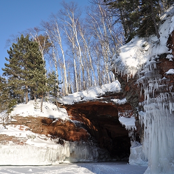
Climb through the icy keyhole arch that opens up into a room filled with a floor of ice and is surrounded by ice. With all the icicles, it looks like a shark’s mouth. As you head farther north, more frozen rooms will appear – such as the “garage,” the largest of the caves, where freezing drips form icicles that hang from the ceiling like a chandelier.
“What makes this so special is because the sandstone is finely layered and has more intricate formations,” says Van Stappen. It’s created by groundwater that seeps through the cave walls and freezes against the cliffs and wave washing.
For ticket prices and the latest conditions, call the Ice Line at 715-779-3398, ext. 3, or check Facebook.
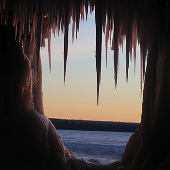
Rock River Canyon Ice Caves
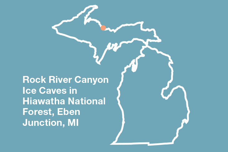
Head north to the Upper Peninsula in midwinter to late winter to see the ice caves inside of Rock River Canyon Wilderness unit in Hiawatha National Forest. Officially they’re called the Rock River Canyon Ice Caves, but almost everyone calls them the Eben Ice Caves.
The self-guided journey begins on private land off Frey Road north of Eben Junction. Park along the road since the landowner is friendly, says Jesse Land, vice president at U.P. Machine & Engineering, Co., who has explored the cave.
Walk an easy quarter-mile across flat, wide-open land through a farmers field that leads to a wooded trail flanked by steep ravines in Rock River Canyon Wilderness unit inside the Hiawatha National Forest.
It’s another half-mile to the ice caves, but be prepared – it’s slippery with steep inclines and exposed tree roots deeper into the forest. “Wear ice cleats,” Land says, “or prepare to fall.”
Listen for the sounds of a babbling creek that runs beside the trail as the path winds up a steep, icy hill. Duck under tree branches and climb up another narrow hill to reach the ice caves.
Officially, the Eben Ice Caves aren’t true caves, says the U.S. Forest Service, but rather curtain-like walls of ice that form after water drips down in colder months, creating ice stalactites off the bedrock.
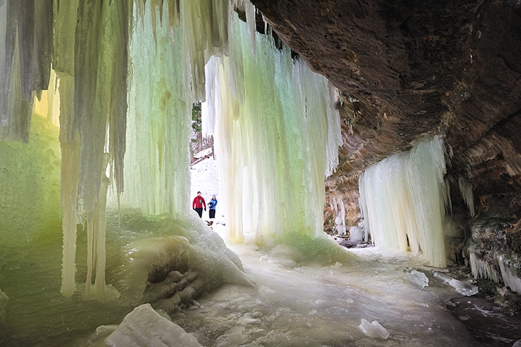
The yellowish, green-hued 60-foot wall of ice is massive, hanging down from a sandstone cliff like an icy curtain showcasing a theatrical play made by nature. Some call it pure magic.
On busy days, ice climbers belay up and down ropes off the sheets of ice. Walk in, out and under the ice formations. Each part feels a little different. The sheer scale and size are colossal. “It is humbling,” Land says.
Enjoy this nearly 3-minute cave tour: